Interactive Google Earth Engine Map (HowTo Use)
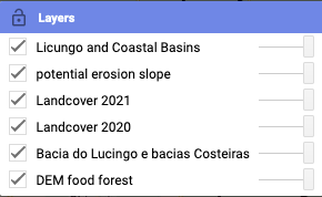
Hover over Layers (upper right Map) to activate Drop Down Menu
Drop Down Menu with layers and the layer order
Check box for enabling and disabling layer

Loading of layers may take some time. A gray indicator line is shown in the layer window in the upper right, expressing the progress of layer loading process. With new zoom level the layers require to load again.

Slide (extreme right) drag with mouse to change transparency of the layer. Opacity 100% with slide to extreme right

To zoom in on map click (+) and to zoom out click (-) on upper left of the map

You can also use the mouse to zoom by scrolling and holding ctrl key (pc) or double click left zoom in and double click right zoom out click and hold with the mouse to snap the map and move
Standard maps provided by GEE. These maps are the bottom layers under the Maji Yetu provided layers:
- A world wide high resolution satellite image (Google Earth) which has a drop down menu (hover over satellite upper right) and click check box.
- Terrain Map with limited labels and 20m contour lines.

An interactive Location Search window facilitates inspection of world wide locations like in Google Earth Satellite Map but is also functional for the Terrain Map. Recognised locations are duplicated in BOLD.
Maji Yetu will limit its layers to the area of interest. For other areas researched by Maji Yetu. For all location monitored by Maji Yetu visit the database.

The scale of the area inspected is in the lower right corner of the GEE image.

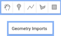
The drawing options cannot be saved but with a screenshot it can be saved for later reference.
You can hide and show the geometries as layers hover over ‘geometry imports’ to show and hide geometries
