ALERT 3, July 29, 2025
MENU
The newest post and image entries are on top of the page. Scroll from the bottom upwards to follow the flow status timeline of the Ruaha River per location
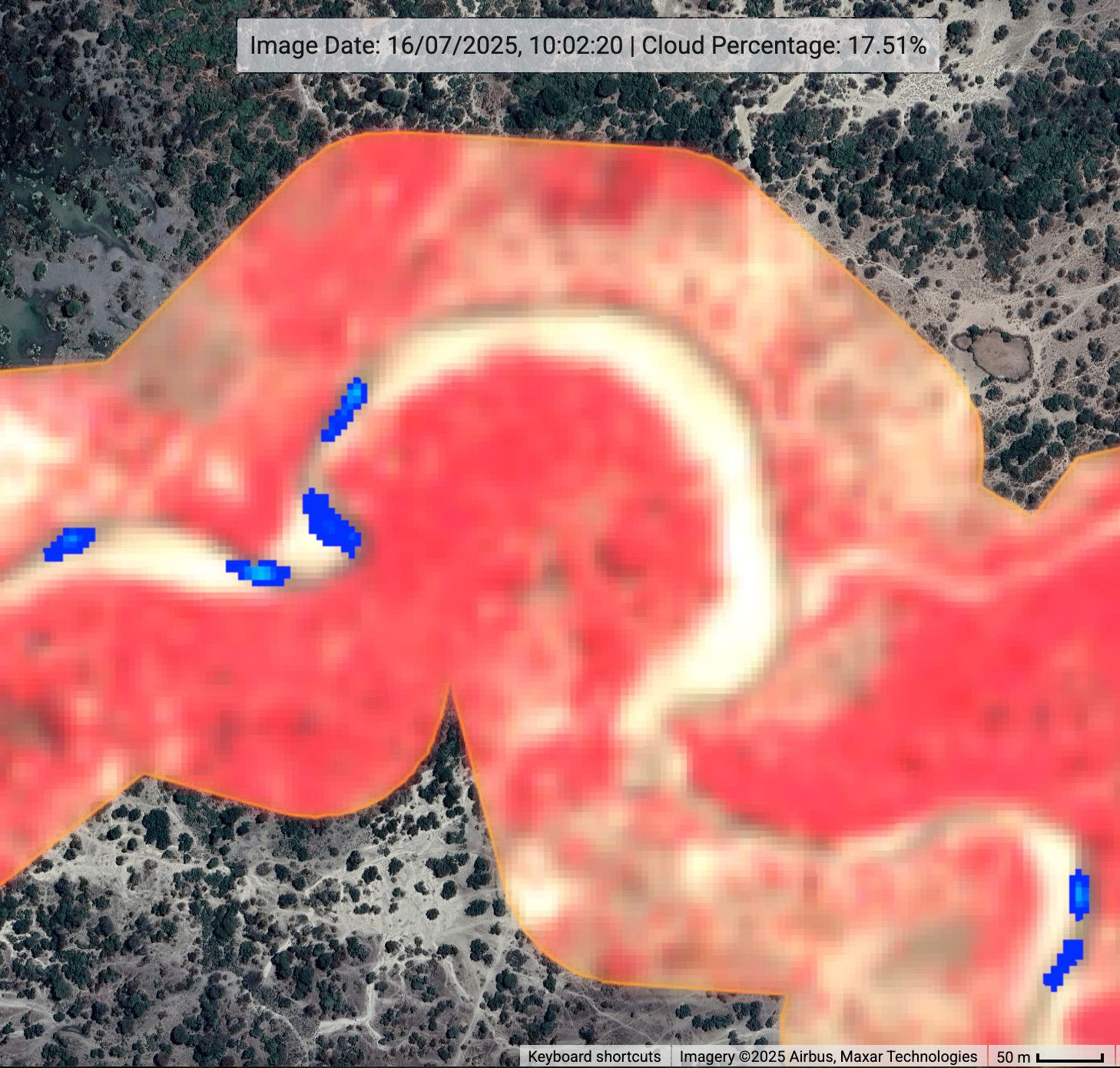
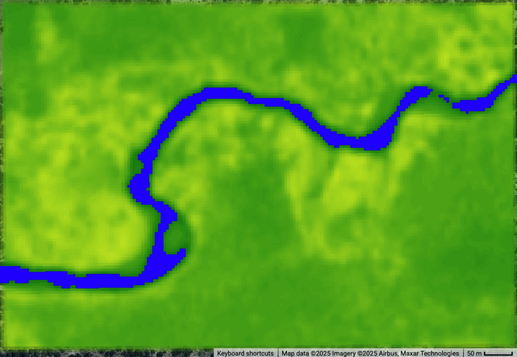
New detection method detects ALERT 3 on July 29, 2025
An individual pixel based detection of water or no-water facilitates the accurate reporting on retreating river channel. The change of water pixel from partial water to land pixel is the basis for this methodology.
Visually detected Zero Flow July 16, 2025 (ALERT 2)
Detail 1st zero flow observation from maji yetu monitor for Ruaha River at Mtera on July 16, 2025. For interactive inspection visit monitor.
Improved Prediction for Alert 1 and Zero Flow in Ruaha now July 10, 2025 at Mtera
The by Maji Yetu created, growing series of historical remote sensing data, improves the accuracy of predicting the first zero flow occurrence in the Ruaha River at Mtera. Two approaches are tested.
(1) Based on satellite rainfall data for the upper reaches of the Ruaha River (Salimwani). Specifically 3IMERGV07 and CHIRP data.
(2) Critically low ‘Water Area” (NDWI 5m/px) reduction with a threshold for reaching Alert 1. Alert 1 is one month before drying of the Ruaha River downstream at Mtera.
Prediction(1) The ‘best’ prediction of the 2025 Alert 1 date (one month before drying Ruaha River at Mtera) is + or – 13.46 days. The area-averaged CHIRPS monthly rain data for non overlapping rainfall periods of September-December, January-March, April-May are used. The selected Ruaha Catchment selected is the Salimwani Ruaha Catchment. The resulting prediction the first zero flow occurrence in the Ruaha River for July 9th, 2025. The Python Script providing the prediction can be downloaded here.
The disadvantage of this method is that it is only available in May. The above method assumed a 0mm monthly for May 2025. Using JAXA GPMap global realtime rain data, 122mm is estimated for the May rains which results in ‘best’ fit prediction of July 13th, 2025 (+ or – 14.09days).
The PRO for the rains based prediction is that it is affected by cloudiness or other weather related setbacks affecting the visual and calculated monitoring method (2). The low accuracy of the rain based prediction is currently a CON but may improve over the years.
(2) The assumed threshold level of 0.012sqkm for the Alert One Ruaha river section is revisited. Visual inspection of the section revealed a river course change in the rainy season of 2020 – 2021. With Sentinel S2-SR (Surface Reflectance) image stretching from 2018 – 2025 a New VDAS ALERT ONE river location is selected in order to have comparable water area values over the maximum period. (visit Alert1 locations on Map). Combining GEE java code to obtain historic NDWI>=0 water area in square kilometers for the selected Ruaha River Section and Python Script for prediction of the 2025 Alert 1 and first zero flow occurrence at Mtera (Alert 2) has output of July 10, 2025 as first Zero Flow Day.

The S2 Top of Atmosphere (TOA) Alert 1 threshold value of 0.012sqkm is replaced by a more robust S2-SR threshold which filters the satellite image on cloudiness inside the tiny 6ha Alert 1 Area of Interest (AoI) which reduces the clarity of the surface reflection and reduce accuracy of water area estimate. The graph indicates the June 10, 2025 Alert 1 date (one month before zero flow downstream at Mtera).
ALERT 1, June 10 2025
Conclusion of the above analysis is the announced Alert 1 date of June 10, 2025, one month before drying of the Ruaha River at Mtera in 2025.
Rainfall data predict zero flow in Ruaha at Mtera end of August 2025 or few weeks later depending on May Rains.
Two freely available rainfall data sets have been tested on prediction of Alert 1 in 2025. IMERGV07 and CHIRP.
Periodic rainfall totals for the upper reaches of the Ruaha Catchment, as the Ruaha is responsible for the low flow in the Ruaha. Overlapping and non-overlapping periods were tested on their correlation matrix (bestfit CHIRPS nonoverlapping) and accuracy in predicting Alert 1 (one month before drying Ruaha River at Mtera) . CHIRPS proved to perform better with an accuracy of +/- 12 days for non-overlapping periods of rainfall (Sep2017-April2025). The release of rain data for May 2025 which may be too late for the prediction of early onset of zero flow. Instead JAXA GPMap daily rain are used to estimate the May rains. Included in the prediction of the zero flow is a minimum rain for May 2025 of 0mm and maximum of 122mm. This difference ultimately narrowed the prediction of the Alert 1 date between July 31, 2025 – +/-12 days (with 122mm rain in May) and August 31, 2025 with no rains in May, 2025. Both the release of the May 2025 data in the upper reaches of the Ruaha River and the actual observation of Zero Flow at Mtera will expose the accuracy of the satellite rain based prediction of the Alert 1 and 2 dates for the Ruaha River in 2025.
Update threshold Alert 1 as low as ~0.01sqkm
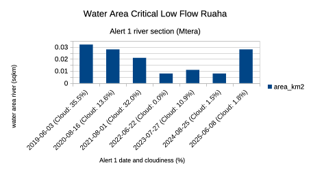
The bar graph above relates the water surface area of the Ruaha to the date of critical low flow (Alert 1). On June 8, 2025 (yesterday), the area is still well above the critical low flow of the river with 0.008 to 0.011 (sqkm) in 2022-2024. In the bar graph the cutting of the river through the river banks at the narrow section (floods 2020-2021) is expressed by the reduction of the water area in 2021. The decline from 0.028sqkm to 0.008sqkm was in the previous years in the range of 3 weeks. Alert 1 is expected to be announced early July. The water area (NDWI) series belows reflects the re routing of the Ruaha river in 2020-2021 in the Alert 1 VDAS river section. Compare with bar graph dates and values. (Click image to enlarge)
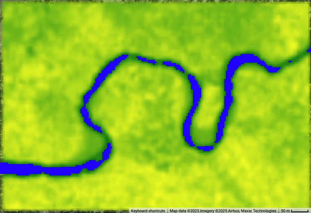
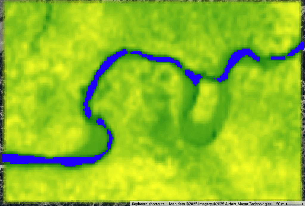
NDWI monitoring Alert1 threshold
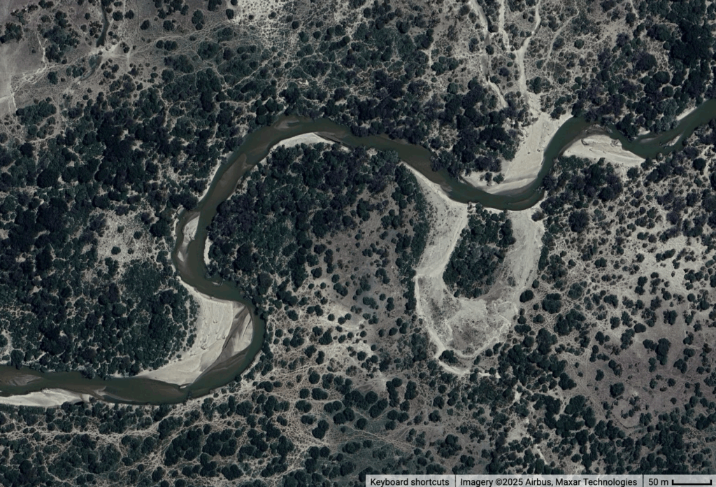
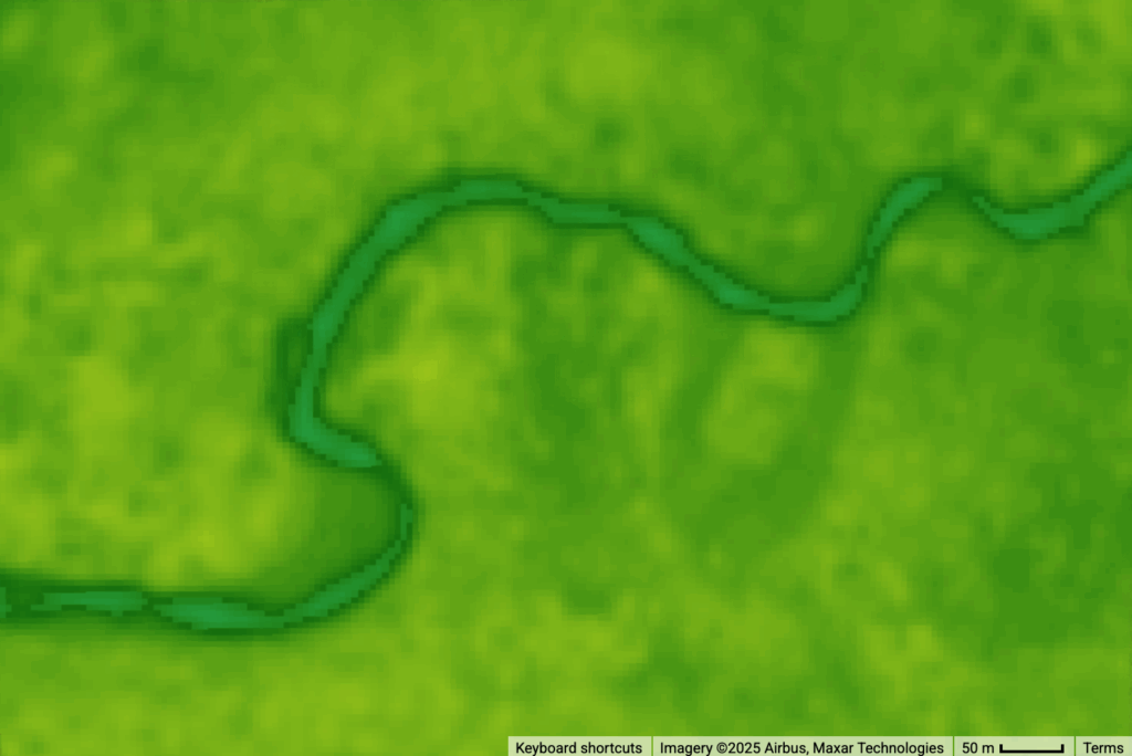
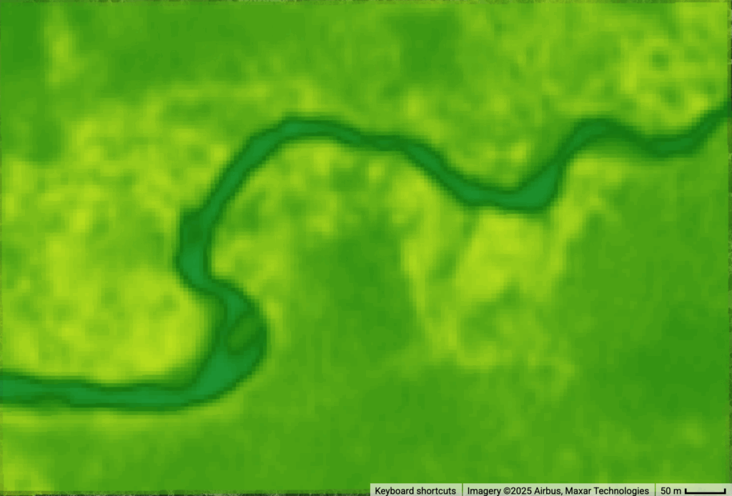
Image series below shows from left to right, high resolution image Alert 1 Ruaha River Section on August 11, 2024, related NDWI resampled water area index on August 20, 2024 of 0.0201 sqkm and June 1, 2025 water area index of 0.0272sqkm, Well above the threshold of 0.012sqkm when Alert 1 is expected. (Click on Image to enlarge)
Alert 1 expected around mid July, 2025
Based on the flow comparison at Mtera (click button <Flow into Mtera Reservoir> in Google Earth Engine Map usangu.majiyetu.org), Alert 1 will be around the second and third week of July, 2025.