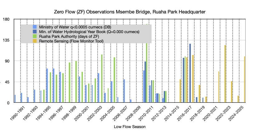
A Total of100days of zero flow at Ruaha Park in 2025.
of zero flow at Ruaha Park in 2025.MENU
History of Zero Flow at Ruaha Park HQ
Last Updated 4 weeks ago
The table can be found here
What is it about and for Whom is it meant?
The Ruaha River Flow Monitor Tool is a web-based tool to learn about the basin’s specific low-flow hydrology through remote sensing (RS). The understanding of the important variables which matter for the river flow, is meant to facilitate the water management authority, in their struggle to mitigate occurrence of Zero-Flow in the Ruaha National Park.
Where did the Zero Flow come from and how to get rid of it?
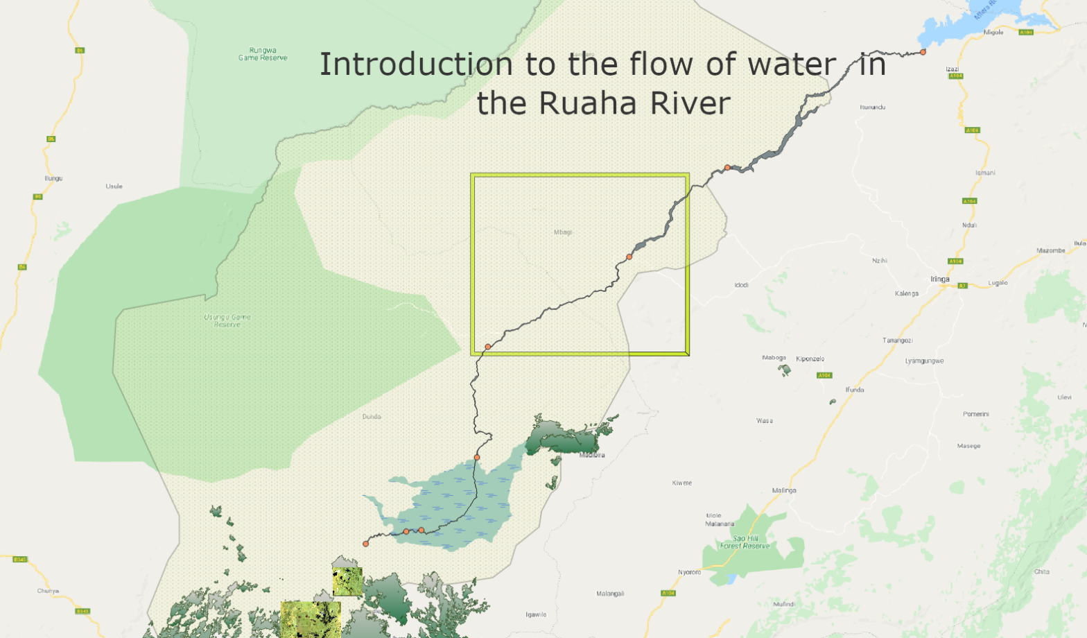
Before any significant area under irrigation was developed on the Usangu Plain, which drains to the Ruaha National Park, zero flow is expected to have occured in the Ruaha River at Mtera as early as the 1950s. This estimate is based on the minimum flow of around ~ 6 cumecs in the Ruaha River at the Park HQ assumed as threshold level for the occurrence of zero flow downstream at Mtera. The location of the river section where zero flow is observed first is some 350km from the source of the Ruaha River.
Human activities in the upper reaches of the Mbarali River Catchment seem to be the most probable explanation for the reduction of the minimum flow in the Ruaha River as it flows through the Ruaha Park towards Mtera. With the development of the rice irrigation (1) the zero flow occurs closer to the source of the Ruaha and (2) the duration of the zero flow periods is also lengthened by the increased abstraction of the low flow from the Ruaha and Mbarali Rivers. The low flow period critical for the occurence of zero flow (no-flow) is outside of the recommended rice irrigation period. The irrigation period starts in November and ends in May/June.
Reduction of the non-essential water abstraction by the numerous irrigation canals on the Usangu Rice Plain, outside of the rice growing season, will already be a game changer for the Ruaha National Park which receives its water from the Usangu Rice Plain. The modest amount of drainage water from the Rice Plain required (~ 4 cumecs) and the fact that it is required outside of the rice irrigation season makes the proposed approach for the combat of zero flow in the park feasible and manageable for the authority. The dramatic reduction (graph) of the minimum flow in the Mbarali River at Igawa, as the river flows from the mountains on to the plain, will need to be addressed.
The rice growing season should start with the onset of the seasonal rains when adequate water becomes available for most farmers to start preparation (pre-irrigation) of the rice fields. The basin authority should announce the start of the rice irrigation after the progress of the rains is considered adequate for a scientifically defined area for rice irrigation based on the forecasted availability of water for each season. At the start of the rainy season the Ruaha and Mbarali Rivers and the return of flow in the many seasonal tributaries, will supply surplus water which sustains flow in the downstream section of the Ruaha beyond the rice growing area into the Ruaha Park and Mtera Hydro Power Reservoir. The canal network can not handle all flow during the rainy season and remaining drainage is boosted.
The water authority will need to intervene when too much rice area is planted which will result in further drop of irrigation efficiency and spill. During the rainy season with excessive abstraction. Not only the refill of the hydropower reservoir but also the occurrence of zero flow is expected to be impacted.
Annual irrigation of rice needs to be related to the availability of water. This obligation is not only in the interest of the fair sharing of the water with downstream users but also in the benefit of the seasonal farmers. These farmers who spend their last money to hire a farm for rice production, are often the first, to find out that excessive planting or poor rains result in inadequate water availability. This is due to the location of the rented rice fields at the end of the (often illegal) irrigation canals. Most of them will return home empty handed.
By limiting the rice growing season to the period of adequate rains the rice development will not challenge the environmental water needs of the Ruaha Park during low flow, in normal years.
The recovery of additional drainage to the Park, which is currently abstracted during the off-season, will be a boost for wildlife and nature. It are only few farms which benefit from this practice with relatively large losses in the canal systems.
As is already exposed by 7 years of remote monitoring of zero flow in the Ruaha River by Maji Yetu a trend of a shortening period between the developed alerts for intervention by the authority to reduce occurrence of zero flow in Ruaha Park, or shorten the “no flow” period. In the longer run zero flow can only be prevented by catchment improvement in the Mbarali River upstream of Igawa and continued stable base flow for the Ruaha during the low flow period.
In order to interrupt the decades old trend of decreased inflow during the dry season (graph), upscaled efforts to prevent the Mbarali River from becoming a seasonal river and a protected status for the Ruaha Catchment (Salimwani) may prove conditional for perennial flow in the Ruaha National Park.
How does the tool work?
Through this website the water management authority are provided with a real time monitor of the flow status of the Ruaha and Mbarali Rivers which matters during the low flow period. Every dry season three Alerts are announced for informing the decision makers about the urgency and scale of water management interventions required to postpone or possibly even avoid the occurrence of zero flow in the Ruaha National Park.
The tool is tested on the “Great Ruaha” River, a tributary of the Rufiji River in Tanzania. The developed RS technology avoids the use of poor low flow data which has obstructed the development of effective hydrological models for water management and the intended prediction and combat of zero flow.
The performance of future dry season water management interventions for perennial flow at the Park HQ on the basis of the provided Alerts by the Ruaha Flow Monitor will also be recorded and improved by the data collected to deepen the understanding of the low flow hydrology of the Ruaha River at Usangu.
