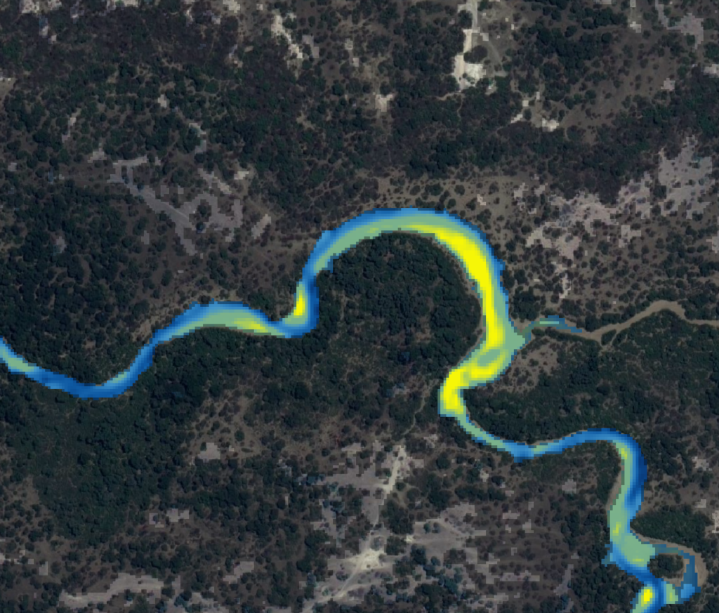
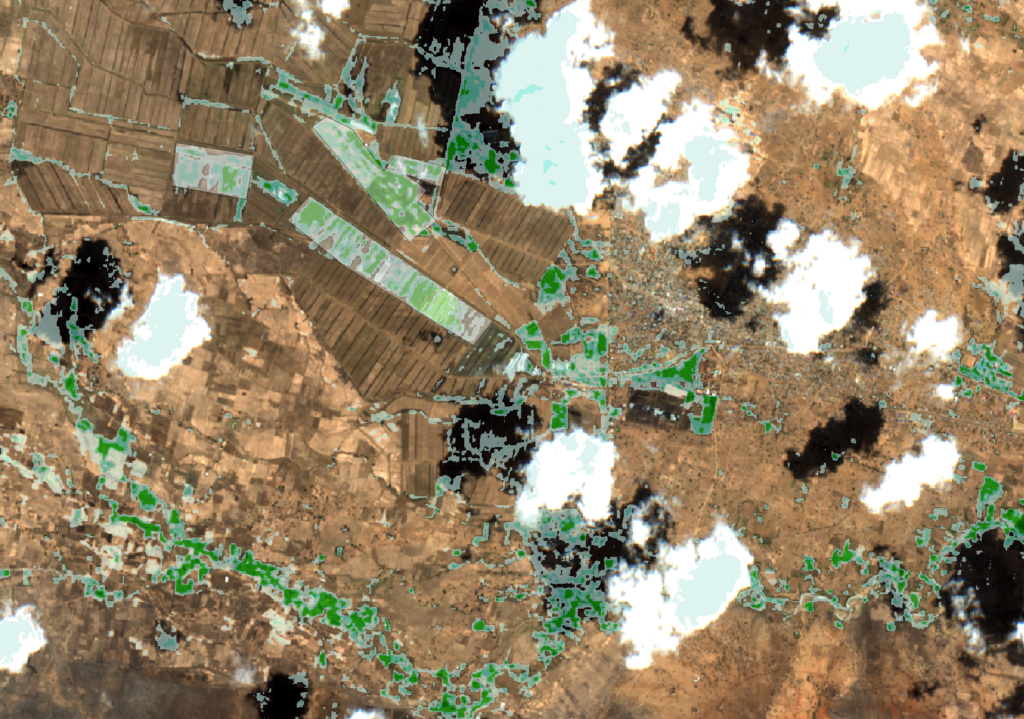
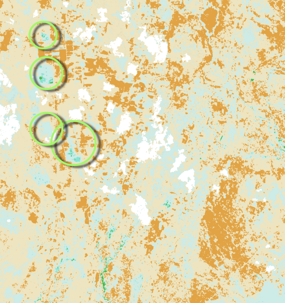
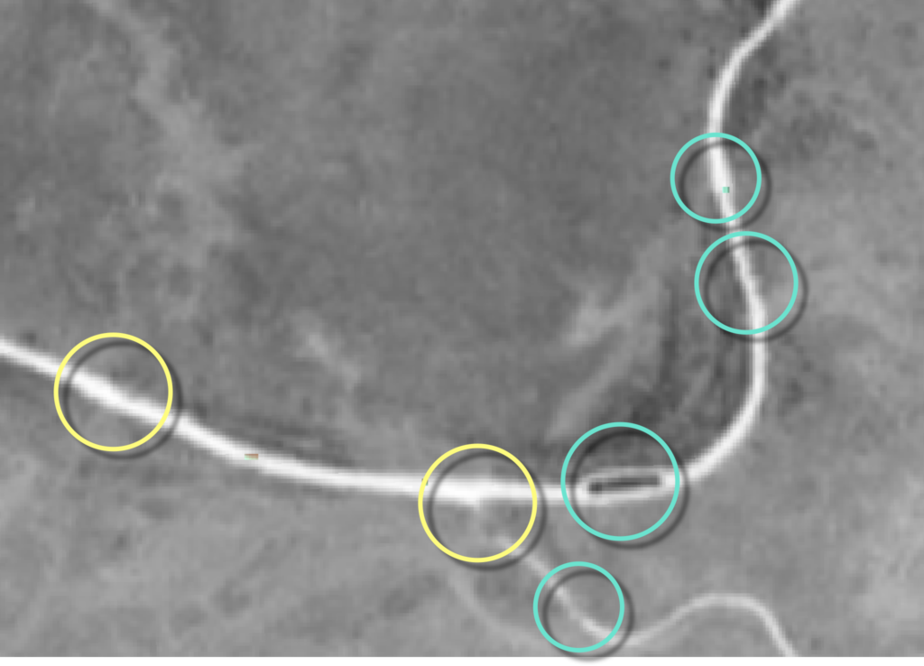
Alert Three on Sept 28, 2023
MENU
The newest post and image entries are on top of the page. Scroll from the bottom upwards to follow the flow status timeline of the Ruaha River per location
Alert Three
On September 28, 2023 the critical drainage flow from Usangu Rice Plain dropped under an assumed 8 cumecs. The current expected period left before zero flow in the Ruaha River at the Park HQ is about one month.
Alert Two
Alert Phase Two connected to the first observation of zero flow in the Ruaha River in the dry season upstream of Mtera Reservoir (Tanzania), is declared on August 26.

Alert One
The period July 27, 2023 and August 8, 2023 had some cloudy days which may have delayed the occurrence of Alert One with one week or more. Alert One is now announced on August 8, 2023. Compare the Landsat 7 images of one month before zero flow at Mtera in 2022 and 2023.


Status Flow Mtera June 7, 2023

Status Flow Mtera June 2, 2023

Status Flow Mtera May 18, 2023
The Ruaha River just upstream of the confluence with the Little Ruaha is still swollen without signs of the upcoming dry season and drying of the river at the selected section of the Great Ruaha which dries first every year.

Mbarali low flow for pre-irrigation
MENU
The newest post and image entries are on top of the page. Scroll from the bottom upwards to follow the flow status timeline of the Ruaha River per location
The images of November 12, 2023 record the initiated irrigation at Mbarali Farm with zero flow at the confluence which means all river water is diverted and utilised for pre-irrigation of the rice crop.


Mbarali River dries
October 18, 2023 is assessed as the date on which the Mbarali River stopped flowing into the Great Ruaha River at the confluence. The confluence is about 220km from the Park HQ at Msembe. The image slide shows the sentinel-2 image with 5m resolution and the high resolution image of the dry Mbarali River coming from the south before it joins the Ruaha River flowing from East to West (left – right).
No Overflow at New NAFCO weir end of August and critically low flow in Mbarali River
Around August 21, 2023, the overflow over the New NAFCO weir in the Mbarali River ceased. Check video on the procedure here.

The Remote Analysis which resulted in the estimated date of August 21, 2023 for the drying of the Overflow at the New NAFCO weir (Mbarali) is summarised by two images after drying of the weir (gallery 1) and two images some two weeks before the drying of the weir (gallery 2).
The georeferenced GIS layers in the first gallery, below represents “No Overflow”. The high resolution top view of the dry weir (no overflow) on December 26, 2021, illustrates the location of the stilling basin (blue box). The remote sentinel color infrared image (5m/px), on the left shows the same location on September 3. 2023. The stilling basin is dry (yellow). The dry stilling basin merges with the dry sediments of the image above.
The second gallery represents the flow status in the Mbarali River just before the ceasing of the overflow on August 1, 2023. The stilling basin is the remote registration of the merging of the dry sand (image above) and the dry bottom of the stilling basin (see high resolution image of December 26, 2021).
The flow in the Mbarali River has dropped to about 2 cumecs when the overflow stops, which is all diverted into the main irrigation canal. At least 1 cumecs should be returned through the return drain 4.6km downstream (as the bird flies).


The leakage flow under the New NAFCO weir and through the sluice gates results in a critically low drainage flow in the Mbarali River. The remote satellite image of September 3, 2023 suggests a low flow resembling the flow status of September 14, 2017. That year the Ruaha dried at the Park HQ on September 23, 2017.


The Mbarali River on September 3, 2023 at the confluence with the Ruaha River Channel, seems to have more water than on September 14, 2017. Possibly from channels connected to the Ruaha River.


Drainage Flow Mbarali River
With most rice farms planted and under irrigation, the Mbarali River is still draining after leaving the irrigated area on May 16, 2023.

Early Irrigation Kapunga – Zero Flow Park HQ
MENU
The newest post and image entries are on top of the page. Scroll from the bottom upwards to follow the flow status timeline of the Ruaha River per location
Expansion pre-irrigation limited by low availability of water in Ruaha
The very limited flow remaining in the Ruaha hampers the expansion of pre-irrigation in Kapunga and Mbarali. The pre-irrigation on November 27, 2023 in Kapunga Scheme, is indicated by green circles. The clouds in the NBR image are masked (white) to distinguish between clouds and pre-irrigation and swamps (blue to green)

Slight increase pre-irrigation with first nurseries
In Kapunga the first rice nurseries can be detected on November 12, 2023 (Click on image). Some of these farms were already pre-irrigated since mid-August. Although the remaining flow in the Ruaha is expected to further decline as the inundated fields are expanding.

Water in Kapunga scarce with few farms pre-irrigate
Eleven days into the zero flow period at Ruaha Park HQ water seems to become limited in Kapunga Ifushiro Area with no significant Early pre-irrigation. Image is compilation of November 2, 2023 (clouded) and October 28, 2023.

Stable Alert3 Irrigation Activity Kapunga
Rice Pre-Irrigation activities did not increase significantly during the Alert 3 period (September 28, 2023). Compare irrigated areas in Kapunga and Ifushiro within blue circles on October 13, 2023 to September 28, 2023 images below .

Recoverable spill and early (pre-) irrigation Alert 3
With the announcement of Alert 3, non-essential abstraction and related spill is observed on September 28, 2023. Compare the areas of pre-irrigation of rice at Alert 3 with the status of abstraction and spill on September 8, 2023


Recoverable water for drainage to Park, 2 weeks after Alert Two
The tracking of early irrigation and spill in the Kapunga area is detailed with the images of September 8, 2023. Some farms in the Kapunga rice scheme have their fields already inundated since August 14, 2023. (see image). Most of the watered vegetation seems to be swamp vegetation associated with spill of abstracted water in lower areas from leaking irrigation canals (Ifushiro area).


Kapunga – Ifushiro flooded fields days before Alert One


Compare Irrigation and Spill end of June and July
The irrigation in the Kapunga commercial scheme is completed and no signs of out-of-season irrigation on July 20, 2023. In Ifushiro some areas are monitored for out-of-season irrigation or spill. Compare the masked NBR image of June 27 (post below) and detail in RGB of an irrigated out-of-season crop or swamp/spill area (400ha)


Please take notice of Clouds and Shades in Mbarali (July 20, 2023)
The masked image above suggests major areas in the Mbarali Sub-catchment with either pre-irrigation or irrigated crop/ spill. As the RGB overlay on the NBR-SAVI masked image demonstrates, are the blue and green areas in the Mbarali River sub-catchment suggesting irrigation or leakages (see video clip) actually clouds and their shades on the ground.

Irrigated crop Kapunga June 27, 2023

Pre-Irrigation and Spill in pools and depressions June 27, 2023
One of the procedures to detect pre-irrigation, spill and pools without vegetation from NBR composite image (Landsat 8 on June 27, 2023). The vegetation is deducted (masked) from NBR as shown in the image sequence below.


Out-of-season Pre-Irrigation or Spill June 15, 2023
Semi-automated tracing of (Pre-) Irrigation (see Video Clip) for the Usangu Rice Plain on June 15, 2023 is demonstrated in the image below. Green – Blue colors are potential pre-irrigation locations of spill through “lost” drainage water to the Ruaha National Park in depressions and pools.

Manual selection pre-irrigation May 31, 2023
The “Natural Color” image of the Kapunga – Ifushiro Area on May 31, 2023 is monitored for Out-Of-Season, early irrigation of rice. Dark fields which could indicate inundated rice fields without crop (pre-irrigation of rice) are analysed using different wavelength band combinations.
The yellow arrows are most probably fields with pre-irrigation or leaking/unattended canals. The white arrow is spill due to depressions/low lying fields. The white circled area is dry possibly burned or rotten crop remains.

Usangu Drainage Monitor
MENU
The newest post and image entries are on top of the page. Scroll from the bottom upwards to follow the flow status timeline of the Ruaha River per location
Alert 3 on September 28, 2023
The drop of the water level in the Ruaha under the level of the branch channel at Nyaluhanga is completed on September 28, 2023. The retreating water from the channel (click for high resolution image) is demonstrated with the sentinel-2 images of August 4 (left image) and September 28, 2023 on the right. The critical drainage flow at Nyaluhanga gauge station with Alert 3 is assumed at 8 cumecs.
Closing in on Alert 3 drainage Usangu Rice Plain
The three images below suggest a water level at the Nyaluhanga Drainage flow station downstream of the Usangu Rice Plain which compares with the Alert 3 levels of 2022 and 2021. On September 18, 2023 the water level in the Ruaha is at some locations (Yellow Circles) below the levels in 2021 and 2022 while other sections of the river seem to hold more water (Blue Circles). This may be explained by changing channels in the river sediments. It is expected that among the upcoming satellite images (September) Alert 3 will be announced.


Drainage Great Ruaha at entrance Ihefu Swamp
Comparison of the drainage status of August 31, 2023 with previous years reveals that the Ruaha holds more water this year than at the same time in respectively 2022, 2016 and 2018. The Ruaha river dried in those years at the Park HQ (Msembe), between end of August (2022) end first week of November in 2018. In recent years with more drainage the end of August (2021 and 2020), flow to the Park HQ was sustained until the second week of November. In 2020 the rains in November prevented zero flow.
The actual zero flow in the Park this year will not be later than the first week of November unless radical boosting of the drainage from Usangu Rice Plain is initiated.


Comparison drainage status end of August 2023 with previous years. The 2020 drainage status at Ihefu was wetter (more flow). No zero flow was recorded (RS) at the Park HQ that year with rains starting in November.


Drainage at Nyaluhanga end of August
Drainage from Usangu Rice Plain update August 29, 2023.

The image slider below illustrates the remote identification (5m/px) of submerged branch canal at Nyaluhanga (Alert 3 threshold). It is assumed that the corresponding water level in the Ruaha River at the time the branches dry, can be related to a critical drainage flow in the range of ~ 8 cumecs. With further drop of the drainage, zero flow at the Park HQ can occur within weeks.
The slider compares the flow status with a dried branch canal (high resolution) with the NDWI composite (Sentinel-2) on August 24, 2023, comparable with the above image of August 29, 2023.
Drainage Usangu Rice Plain not yet critical (Alert 3)
The declaration of Alert 2 on August 26, 2023 moves the focus to the drainage assessment from the Usangu Rice Plain. The adopted critical threshold drainage flow in the Ruaha at the Nyaluhanga gauge station of around ~ 8 cumecs is associated with the drying of a branch channel at Nyaluhanga. The high resolution google earth image of June 25, 2009 reflects this critical flow status. As soon as the branch channel dries Alert 3 is announced.
Under Alert 3 there is very limited time left to address the inadequate drainage from Usangu to the National Park through management interventions. In a matter of a few weeks the river will dry 100km downstream in the Ruaha National Park.
Currently the drainage flow is still above the critical flow associated with Alert 3 as is illustrated by the sliding image below. The flow status is from August 24, 2023.
Comparison Drainage 2023 at Nyaluhanga
The drainage on August 4, 2023 (left) compares to July 11, 2018 as is demonstrated by the two images of the Ruaha River section. In 2018 the period of zero flow at the Park HQ (Msembe) lasted 36 days and started on November 7, 2018.


Comparison Drainage 2023 with previous years
Drainage in the years 2016, 2018 and 2020 resemble to more or less extend the 2023 drainage pattern of 2023 into the dry season.


The decline of drainage flow in 2023 is monitored in order to find dry season flow patterns comparable to 2023.
Drainage Monitor since April 4, 2023
Assuming that before 2023 no low flow management interventions programme existed, comparable dry season drainage patterns before the occurrence of Alert 1, may provide some indication of delayed or even absence of zero flow as a result of the programme. The tested method assumes that increased drainage from the interventions as compared to the “non-intervention” drainage of the reference year will be reflected in the comparison of the occurrence of zero flow at the Park HQ in 2023-2024 with the dates of the pre-project reference year.
From early April 2023 onwards the decline of the drainage is monitored and ressembles the dry season of 2018. Also 2016 is comparable but seems to be wetter early June as compared to 2023 June.

Overflow from N’giriama returns
MENU
The newest post and image entries are on top of the page. Scroll from the bottom upwards to follow the flow status timeline of the Ruaha River per location
Flow from Ihefu Swamp returns between November 29 and December 2nd, 2023


Zero Overflow 17.5km downstream Ng’iriama
On November 27, 2023 the Ruaha has dried 17.5km downstream (as the bird flies) of the Ng’iriama SIll. It is assumed that the overflow has also ceased at the outflow of the swamp on November 27, 2023 but possibly some days earlier.
Zero Overflow at VDAS (Idunda)
On November 19, the overflow from the Ihefu swamp does not any longer reach the Idunda VDAS (Virtual Drainage Assessment Station) 30 kilometers downstream of the Ng’iriama Sill.


Imagery end October suggests increased overflow
Check of the rainfall in the period preceding the period between October 23 to 30, 2023 confirms that suggested increased flow (October 30) are visual deceptions. The MNDWI (Band11-B3)/(Band11+B3) proves to be more reliable on inspection as is demonstrated by both image sliders below.

Comparison Color Infrared images of October 23 (after) and October 30 (before) to show the reflection on the water surface which may suggest zero flow.
The MNDWI raster on both October 23 (see image gallery previous post) and October 30, 2023 provide the most accurate information on the actual flow status of the Ruaha River between the Ihefu swamp and the Park HQ.
Near zero overflow 31km downstream of Ng’iriama Sill
With detectable flow some 17.5km downstream of the sill, at VDAS 405 (31km) flow seems to dissappear in sediments on October 23, 2023. The upcoming image for the Park HQ may confirm the drying of the Ruaha River in the Park (Msembe Bridge).


De image slider below combines the high resolution image of the Ruaha River between the swamp and the Park Headquarter, at the time the minimal flow from Ihefu swamp gradually dissappears in the sediments on its way to the park HQ.
At the time, still some surface flow is distinguished 17.5km downstream of Ngiriama as on the image of October 23, 2023 below, the surface flow gradually dries further downstream as the above images suggest, possibly recovering here and there with groundwater contributions stored along its banks making still its way to the Msembe Bridge (Park HQ).
Overflow Ihefu Swamp stable mid-October 2023
The overflow from Ihefu swamp seems stable since end of September, 2023. Compare flow over 130m long section of the Ruaha River downstream of Ng’iriama on October 13, 2023 with September 25, 2023, below

Overflow Ihefu Swamp end of September 2023


Comparable Overflow Pattern 2021 and 2023
The comparison slide which compares the Ruaha River section downstream of the Ihefu swamp on July 20, 2023 (left) and August 4, 2023 clearly shows the reduction of the flow and pools in the riverbed. (yellow circle) The flow in the Ruaha on August 4, 2023 compares to August 23, 2021 as shown in the high resolution image f. In that year the Ruaha River dried on November 19, 2021 at the Park HQ (Msembe) and the overflow from the Ihefu swamp stopped on December 9, 2021.
Like the attempt to find years with resembling Ruaha River flow (decline) pattern at the entrance of the Ihefu swamp (monitor drainage), also the decline of outflow from the Ihefu swamp may follow comparable patterns. The images below shows that the current overflow (July 20, 2023) exceeds the flow on August 23, 2021. In that year the overflow dried early December.


Overflow at N’giriama on June 20, 2023

Overflow N’giriama Early June 2023
Some 2.5km downstream of the Ihefu Swamp N’giriama Sill several channels over the base rock are still feasible early June 2023.

Flow Returns in Ruaha at Park HQ but may dry again
MENU
Last Updated 1 year ago
The newest post and image entries are on top of the page. Scroll from the bottom upwards to follow the flow status timeline of the Ruaha River per location
In the absence of sustained seasonal rains the Ruaha River at the Park HQ may dry again. Below the flow status on December 24, 2023 at the Msembe bridge is shown.

Flow Returns after estimated 46 Days at Park HQ
The remote rainfall data of local storms during the period November 30, 2023 and December 5, 2023 suggest return of flow on December 2nd, 2023. Compare the flow status of November 29, 2023 (Zero Flow) and December 5, 2023 (Flow) below. Added are the local rainfal data during the same period at Jongomero Camp (upstream of Ruaha HQ) and the Kapunga Area some 100km upstream (as the bird flies).


Backward correction Zero Flow due to recent cloudiness
The availability of the October 30, 2023 image with a clear view of the msembe bridge (Park HQ) has resulted in the re-analysis of the October 2023 imagery and assessed October 17, as the zero flow date in the Ruaha River in 2023. All images below have gamma value 2 and the 15m pixel Landsat 8 image of October 17, 2023 has increased contrast.


October 26, 2023 Zero Flow expected within days
The analysis of the 30m Landsat image of October 26, 2023 is not conclusive while it does not show the details of the resampled (5m) sentinel-2 image. On October 30, 2023 the higher resolution sentinel-2 will be available which can conclude on the zero flow at the Park HQ. The three images show the remote sensed flow status of the Ruaha River at the Park HQ (Msembe Bridge) respectively 2 days before zero flow (2018) at zero flow in 2022 and the current status from the Landsat LC08 image of October 26, 2023.


Zero Flow Park HQ expected end of November
The flow status at the Park HQ on October 15, 2023 is comparable with the flow status of July 12, 2022 and October 1, 2018. Zero flow was observed in those years almost 40 days later. (Click on image to enlarge)

Re-assessment flow at Park HQ in 2023
Comparison of the flow in the Ruaha in June and July 2023 with the high resolution image at the Msembe Bridge (Park HQ) reveals that the flow early July exceeded the amount in 2013. Which pushes the expected zero flow occurrence at the Park HQ beyond the first week of November 2023. The image slider shows the flow status (before) which compares to the high resolution image taken 4 days later on July 10, 2013. The second image is the flow status 10 years later. The comparison shows the higher water level in the pool upstream of the bridge in July 2023.
Flow status Great Ruaha at Park HQ June 2023
Since January the Ruaha is flowing under the Msembe Bridge at the Ruaha Park Headquarter. The Ruaha dried at end of first week of November in 2013 (high resolution image right) while the Ruaha had more water one month later than the current flow, according to the visible water level. The current flow at the Park HQ suggests an earlier date for zero flow in 2023 without interventions.


Ruaha flow at Mtera recovers January 2024
MENU
The newest post and image entries are on top of the page. Scroll from the bottom upwards to follow the flow status timeline of the Ruaha River per location
The sporadic rains and delay of the seasonal rains resulted in a new dry spell and zero flow in the Ruaha at Mtera during the end of December 2023. Although cloud cover in January 2024 reduces the reliability of the observations it is expected that around January 8, or following days the flow at Mtera has recovered. Images some 82km upstream of the VDAS of Mtera shows increase of flow on 20m pixel Sentinel composite (Land and Water Band Red8, SWIR1, Red).


Ruaha dries again at Mtera
After the flow returned in the Ruaha River from local rains it dried again in the absence of sustained seasonal rains in the upper reaches of the Ruaha and Mbarali River Catchments. The flow status of the Ruaha at the Alert 2 VDAS River section, shows the remaining pools in the drie riverbed.

End zero flow period Ruaha at Mtera
On December 6, 2023 the water front in the Ruaha has reached at least 20 km from the VDAS at Mtera, according to the nearest Landsat 7 image. As all landsat satellites cross the equator in the morning hours, it is estimated that on December 6, 2023 the flow returned at Mtera.


Alert Two
Zero flow at Mtera is observed on August 26, 2023. Alert phase two is declared for reduction of non essential abstractions from the Mbarali and Ruaha Rivers on the Usangu Plains. The images in the slider below include the pre-zero flow status of the Ruaha River at Mtera on August 21, 2023 and the first day on which zero flow is observed (August26, 2023).

New Procedure Low Flow Analysis (remote flow monitor)
For the development of standards for low flow analysis, the sentinel L2A band 8 is selected. To replicate the natural environment of the flow the Ruaha River channel is extracted by the normalised difference water index (NDWI). The result of this new procedure is demonstrated in the image slider below. The resampled 5m pixels are compared with the color infrared composite from EOS of August 21, 2023.

Alert One
The period July 27, 2023 and August 8, 2023 had some cloudy days which may have delayed the occurrence of Alert One with one week or more. Alert One is now announced on August 8, 2023. Compare the Landsat 7 images of one month before zero flow at Mtera in 2022 and 2023.


Flow Ruaha River at Mtera July 27, 2023

Flow Detail “Alert 1 Section” Ruaha River July 22, 2023


Flow Detail “Alert 1 Section” Ruaha River July 17, 2023
Compare the flow on July 17, 2023 with the flow status in the Ruaha one month before the first zero flow observation at Mtera in 2022. The two magnified river sections are respictively from July 17, 2023 and June 17, 2022 which latter flow was recorded one month before the drying of the river. It suggests that zero flow is not expected before the second half of August in 2023.


Flow on July 12, 2023

Flow on June 27, 2023

Flow on June 20, 2023

Flow on June 17, 2023

Flow Comparison Mtera
One cloudless section of the Ruaha some 2 km long as the bird flies, is compared on June 7, for four years, with 2020 some days later on the 11th of June.
The upper image had the first occurrence of zero flow on July 17, 2022 and the lowest image the last occurrence on September 15th, 2020. According to the current flow status in 2023 the predicted zero flow occurrence this year is between July 17 and August 31. Successful intervention in the regulation of additional drainage from the Usangu Rice Plain may postpone the occurrence of zero flow at Mtera.


Status Flow Mtera June 2, 2023

Status Flow Mtera May 18, 2023
The Ruaha River just upstream of the confluence with the Little Ruaha is still swollen without signs of the upcoming dry season and drying of the river at the selected section of the Great Ruaha which dries first every year.
