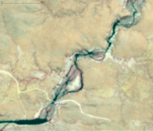
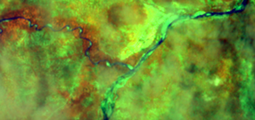
Almost Real Time Ruaha River Flow Status – 2022


Ruaha River Flow Monitor Tool (Remote Sensing) Zero Flow Period 2022 around 124 Days at Ruaha Park HQ.

Last Updated 7 months ago

Alert Three 2022

Last Updated 7 months ago

The newest post and image entries are on top of the page. Scroll from the bottom upwards to follow the flow status timeline of the Ruaha River per location

Zero Flow at the Park Headquarter is expected early in the year around mid-August 2022 The zero flow period at the Ruaha Park HQ will be probably be a long zero flow period starting already early in the Ruaha low flow season.

Analysis of the flow status at Msembe Bridge through comparison with earlier low flow series (2018) predicts the first zero flow between 7 to 17 days from today (August 6, 2022)

The Flow Status in the Ruaha River on August 6, 2022. The River has less discharge than on October 21, 2018 (image below) at 17 days before zero flow at the Msembe Bridge on November 7, 2018. (click to enlarge)
The flow status on October 21, 2018, seventeen days before zero flow at the Msembe Bridge (Ruaha Park HQ). (click to enlarge)
The Flow Status in 3m resolution (PlanetScope) on October 22, 2018. Comparable with the current flow status early August 2022. Which means that the river will dry 2 months earlier than in 2018 at the Park HQ. In 2018 the length of the zero flow period was approximately one month (RS).

Alert 3 starts from July 30, 2022 drainage less than 8 cumecs at Nyaluhanga

Alert 3 Drainage Flow drops under approximately 8 cumecs on July 30, 2022

Alerts one and two 2022

Second Alert defined as the first day of zero flow in the Ruaha River at Mtera is assessed between July 12 and July 17 2021. This last date is selected for Alert Two. Check below the flow status on respectively July 17, 2022 (Alert Two) and on July 12, 2022 as the flow nears zero flow.

Zero Flow in the Ruaha River before it is supplied with water from the little Ruaha at the confluence in Mtera on July 17, 2022 (click to enlarge)
Near Zero Flow in the Ruaha Section before it meets the Little Ruaha at Mtera on July 12, 2021

The First Alert for the Rufiji Basin Water Office to start following the water use in Kapunga and Ifushiro is announced on June 12, 2022

The Flow Status 2.25km (as the bird flies) upstream of the early zero flow section of the Ruaha River at Mtera one month before the occurrence (Alert One) on June 17, 2022 (click to enlarge). Compare with the 2021 Alert Image on July 17, 2021 below.
Alert One flow status in the Ruaha River at Mtera on July 17, 2021 for comparison with the 2022 Alert 1 status

Suspected Zero Flow Mbarali December 4, 2022

Last Updated 1 year ago

The newest post and image entries are on top of the page. Scroll from the bottom upwards to follow the flow status timeline of the Ruaha River per location

While images with cloud covers blocked the view and suggest rains, the images below downstream (3.3km) of the New NAFCO Headworks at Mbarali suggest zero flow on December 4, 2022. With a resolution of 5m/px flow may still be present without sentinel able to capture the near to zero flow.

Usangu Drainage Contribution Mbarali ceased

At the confluence of the Ruaha River and the Mbarali River in the Ruaha National Park, the drainage from the Mbarali River has ceased. You can compare the 10m/px sentinel image of September 3, 2022 with the high resolution image of November 15, 2011 where you can find the exposed sediments of the riverbed inside of the yellow circles.

Natural Colors for the Sentinel 2 image of September 3, 2022. A scale is inserted wat the top left. (Click to enlarge)
The same location on a high resolution image from November 15, 2013. (Click to enlarge)

Contribution Mbarali River to Drainage Usangu almost Nil

Section Mbarali River on August 29, 2022 less than a kilometer from the confluence with the Ruaha River at the top of the image where first observation of zero flow occurs. See below for details. Click on image to enlarge.
Detail above image see scale in upper left corner. Click to enlarge, the pixels are 5mx5m.
High resolution impression of same section Mbarali River on November 15, 2013.

Overflow at New NAFCO Mbarali zero to near zero August 19, 2022

For the analysis of the near infrared image (5m/px) at New NAFCO weir visit this link.

Almost all low flow from the Mbarali is diverted into the main canal on August 19, 2022.

Overflow Status Mabarali New NAFCO Weir August 2022

The Estimated Flow in the Mbarali on August 6 2022, is more than 2 cumecs, based on the RS analysis. Two cumecs is the assumed minimum diversion flow to the Mbarali Hydro-Power Station, Town and Irrigation Scheme. The remainder of the flow in the Mbarali river is the overflow over the weir. The return canal is also holding water (see image) and 1 cumecs is the regulatory discharge in the drain to be returned to the Mbarali main channel. The discharge cannot be verified remotely by the Ruaha Monitor Tool. The absence of return flow and approximate full drain can be assessed remotely during the low flow period in Mbarali River. For details about the remote assessment visit the related page.

Compare the enlarged version (click to enlarge) of the overflow over the New_NAFCO weir. The reduction of the turbulence (=discharge) over the weir due to the reduced low flow in the river, can be observed with the recent overflow images of July 30, 2022 and July 25, 2022 respectively (see July images below).
Mbarali New NAFCO main canal with blue arrow for the direction of the return flow into the Mbarali River Main Channel On August 6, 2022. (click to enlarge image)

Flow Status Mabarali New NAFCO July 2022

End of July the overflow at the weir in the Mbarali River at the new NAFCO intake still exceeds an estimated 2cumecs. The overflow is reflected by the turbulent whitish overflow section of the weir.

Compare the weir section on this image darkened by the cloud shadow on July 30, 2022 with the same location on the image below with comparable overflow.
The overflow over the weir at the New NAFCO intake of Mbarali River on July 25, 2022. (click to enlarge) For the high resolution image of the overflow see image below.
The images with high resolution and 10m pixels (Sentinel-2) of the New NAFCO Intake in the Mbarali River are both taken on June 23, 2019.

Increased River Flow abstracted no overflow Ihefu

Last Updated 1 year ago

The newest post and image entries are on top of the page. Scroll from the bottom upwards to follow the flow status timeline of the Ruaha River per location

The considerable increase of irrigated area on January 2, 2023 as compared to the December 17, 2022 irrigated area is enabled by the first rains allowing more abstraction from the Mbarali and Ruaha Rivers (green and light blue colors in irrigated area). On the same day as the NBR composite image below (Landsat 8) of January 2, 2023 the drainage from the Usangu Rice Plain together with possible supplies from tributaries does not suffice yet to reach the N’giriama outlet of the Ihefu swamp.

Increased Rice Irrigation from the two main diversion weirs at Kapunga (Ruaha River and New NAFCO (Mbarali River) respectively the left and right highlighted (white) areas on the image below, seems to benefit from the increased flow in both rivers while the Drainage flow from the Usangu Rice Plain does not suffice to cross the Ihefu Swamp.

Compare the Kapunga Irrigated Area on December 17, 2022 with the image below of December 12, 2022

Usangu Rice Plain experiences very dry season 2022

It is expected that there is some more water in the Ruaha but still inadequate to launch the rice irrigation season. The 1 to 2 cumecs abstracted in Usanga for selected group of farmers (light blue and tones of green) in the highlighted (redish) Kapunga Commercial Farm would boost drainage to the water starved Ruaha National Park.

Kapunga Rice Irrigation on some few farms in total an estimated 400ha of the total 3,600ha. The image is on December 12, 2022.
Pre-crop season irrigation attempts (end of August) are doomed to fail with the early onset of the zero flow period at Usangu and Ruaha Park. Compare early rice crop on October 23, 2022 with planted crop on NBR image of August 24, 2022 (below). Also comparison with the October 29, 2019 image of Usangu Rice – Kapunga shows the dryness of 2022 due to early onset of the zero flow period.

Start Zero Flow Period Park HQ 2022 – 2023

With the start of zero flow period at Msembe Bridge (Park HQ) irrigation and spill in the Usangu Rice Plain is due to the low flow limited to mostly spill. The Kapunga Smallholder and Kapunga Commercial Scheme have been indicated and to the west spill in the uncontrolled canal network of Ifishiro also low areas with spill can be detected on August 21, 2022.

Near Infrared Sentinel-2 on August 24, 2022, with smallholder rice scheme on the left and Kapunga Commercial Farm in the center. On the right is the “informal” Ifushiro Rice Area with related spill. The difference between pre-irrigation and burnt farms can be distinguished in the image below. Click to enlarge.
The green and dark blue colors represent either rice crop, swamp and grasses from preirrigation and spill water. Dark brown areas are burned fields. The image is three days after zero flow started at the Park Headquarter at Msembe, on August 24, 2022.

Usangu Diversion and Spill August – July 2022

The use and spill of river water during the low flow period in the Ruaha River at Kapunga and Ifishiro Rice Plain and Diversion of the Mbarali River at New NAFCO Intake is monitored. The Ruaha Flow Monitor finds Irrigation and Spill hotspots and the authority will need to follow up on these hotspots. In case irrigators do not have the required permit to abstract or spill is the result of neglect both losses will be easy to recover for drainage to the park. Increased drainage during the critical low flow period (Three Alert Phases) will prevent or reduce the period of zero flow in the Ruaha Park (Park Headquarter).

With very limited time left to boost drainage before it is too late to prevent zero flow at the Park HQ, which will start within one to two weeks from now (August 11, 2022), limited resources are left, to adequately improve the low flow in the Ruaha River in the Park. Early drainage increase measures (during Alert One) will be required to delay the start of the zero flow period. With timely start of the rains and timely start of drainage management measures, zero flow can be avoided. On August 4, 2022 some spill hotspots are demonstrated using RS. (see two images below for August). For more details about the tracking down of (uncontrolled) Irrigation, Spill and Riverine “losses” click here.

Near Infrared Image of Ifushiro Area (Kapunga, Usangu Rice Plain) on August 4, 2022 shows stagnant pools bootom center and center right, the dark reds are swamp vegetation and dark brown-black are burned fields or saturated (swamp) soils. Watch Out for the dark shadows of the White Clouds. The color composite of NBR sentinel-2 images (below) is a good indicator of the spill, irrigated and riverine vegetation areas of Usangu Rice Plain. (click to enlarge)
NBR Sentinel-2 representation of the water spill areas shown in NIR image above. Dark and Light Green, Dark Blue correspond well with stagnant water, swamp vegetation (red in NIR) and saturated soils (swamp, irrigation canal leakage). Dark brown (indicate burned fields) not observed here. Clouds may leave light blue colors on NBR and need to be distinguished from atmospheric loss of ground and surface water in swamps and vegetation.

Irrigation and Spill with Alert 3 announced on July 30, 2022

Currently (July 2022) an irrigated area in the Ifushiro section of the Ruaha should be questioned already deep into the alert (phase) 2 and on the day alert alert (phase) 3 is announced.

Water is supplied by a branch of the Ruaha.

Irrigated Fields or unattended canals with crops or weed contributing to spill on the Usangu Plain during low flow in the Ruaha and Mbarali Rivers and the occurrence of zero flow due to reduced drainage from the plain on July 30, 2022. The scale fro the image is on the upper left. Compare the high resolution image below of the same area but 5 years earlier when the same phenomena of spill occured.
The same area in Ifushiro on July 24, 2017 in high resolution. (click to enlarge)

The practise of having water in the drainage system of the major rice schemes can be considered as loss as long as this water is not return flow to the Ruaha or Mbarali Rivers. Even if it the drains are used to return water to the main river channels abstraction of water from the drains should be avoided. Not only is registration and management of such diversions difficult, it also provides a precedent for illegal use of water by others. These “informal improvisations” in the system can often be associated with spill especially in the Ifushiro area where natural depressions, are likely to fill and become hotspots for spill each low flow season.

Water diverted from the drains of the Kapunga rice schemes (commercial and small holders) on July 30, 2022, is either used for irrigation during the low flow period of the Ruaha or spilled due to unattended diversion.

Drainage Flow Returns November 12, 2022

Last Updated 1 year ago

The newest post and image entries are on top of the page. Scroll from the bottom upwards to follow the flow status timeline of the Ruaha River per location

Drainage flow on November 12, 2022

After some two months of zero drainage at the Nyaluhanga – Ihefu Swamp section of the Ruaha River drainage flow has returned on November 12, 2022. Compare the two images below, at the same section of the Ruaha approximately 13km (as the bird flies) downstream of the Nyaluhanga Gauge Station.

Return of Drainage some 13km downstream of the Nyaluhanga Gauge Station on November 12, 2022 in natural color. Compare with image below where the riverbed is exposed on two locations. The width of the image represents some 2km. (Click to enlarge)
The same section of the Ruaha River on October 13, 2022 with two stretches of riverbed exposed as result of the zero flow. The submerged sections reflect pools in the river channel. (Click to enlarge)

Zero Drainage September 5, 2022

Seven sections with exposed riverbed during sustained 40 day period of zero drainage on October 13, 2022 in the Ruaha River at the entrance of the Ihefu Swamp (Eastern Wetland)
First observed zero drainage in 2022 on September 5.

Usangu Plain Still Drains water in the Ruaha River September 18, 2022

Still some Drainage flow from the Usangu Rice Plain is entering the Ihefu Swamp concluding from the drifting reet fields. Compare the images at the entrance of the Ihefu Swamp of the Ruaha River on September 3, 2022 and the same section on September 18, 2022 below. The circles enclose the reet fields which have moved downstream in the period between 3 to 18 September 2022. In this period thre new reet fields formed in this section of the Ruaha River.

Two weeks later than the image below (September 18, 2022) the reet fields have floated downstream but three new reet fields developed in this period. Indicating that there is still drainage flow. But not adequate to cross the Ihefu swamp and Ng’iriama Sill where the flow has ceased.
The sentinel-2 image of September 3, in natural colors shows two reet fields in the Ruaha River close to the entrance of the Iheful Swamp. (click to enlarge)

Nyaluhanga Usangu Drainage, Start Alert 3 on July 30, 2022

The Drainage from the Usangu Rice Plain which results in zero as soon as it drops under a critical value, is monitored at the confluence of the Mbarali River and Ruaha River and downstream at Nyaluhanga gauge station up to the entrance of the Ihefu Swamp. Alert Three starts as soon as the water level drops under approximately 8 cumecs and little time is left to boost the drainage further to delay the start of the zero flow period at the Park HQ.

On July 30, 2022 Alert Three is assessed (RS) to have started with the drop of the discharge at the Nyaluhanga Gauge station or more accurately with the drying of the branch of the Ruaha River
Flow at confluence Mbarali and Ruaha River ion July 30, 2022.

Low Flow Drainage 2022

Nyaluhanga Gauge Station on July 25, 2022 Some traces of water in branch left compare image of July 30 and July 10, 2022.(click to enlarge)
Traces of surface water in the branch of the Ruaha River at Nyaluhanga Gauge Station on July 15, 2022 with estimated flow exceeding 8cumecs.(click to enlarge)
Surface water in the branch of the Ruaha River at Nyaluhanga Gauge station clearly visible at the bottom left. The NIR sentinel-2 image with manipulated 5m pixels is from July 10, 2020. (click to enlarge)

The newest post and image entries are on top of the page. Scroll from the bottom upwards to follow the flow status timeline of the Ruaha River per location

Flow in the Ruaha River under the Msembe Bridge (center of image) on January 23, 2023. The image corresponds with 3.2km in the width. (Click to enlarge)

Surface overflow advancing to Park HQ

The surface flow in the Ruaha River between N’giriama and Msembe (Park HQ) slowly advances. On January 8, 2023 there is still a section of the river 21.3km upstream of the Msembe Bridge with zero flow from the Ihefu Swamp while water supplied from local cachments already flows under the bridge.

The dry section of the Ruaha River on January 8, 2023. The width of the image is 4km and located some 21.3km upstream of the Park HQ (Msembe Bridge). Click image to enlarge.

The overflow from Ihefu Swamp still did not reach the Park HQ on January 6, 2023 (see image below) while flow downstream of the inlet at the Park HQ continued at least on January 3, 2023.

Zero Flow from Ihefu Swamp at 38.5km as the bird flies upstream of the Msembe Bridge (Park HQ) on January 6, 2023. The width of the image corresponds with some 2.5km.

Zero Overflow Ihefu Continues in 2023

On January 2, 2023 zero overflow from Ihefu swamp continues, according to Landsat 8 image of same section of the Ruaha River as the Sentinel-2 image below of December 17, 2023. The Ruaha River section is 9.7km downstream from the N’giriama Sill (as the birds flies).

The drainage from the Usangu Rice Plain is still not adaquate on December 17, 2022 to reach the outflow of the Ihefu Swamp, although abstraction for rice irrigation seems to increase according to the expanded inundated area at the two main irrigated schemes on the Usangu Rice Plain

The isolated pools in the Ruaha River downstream of the Ihefu Swamp outlet on December 17, 2022 indicate absence of overflow sustains. (Sentinel-2)

Although cloud cover suggest the arrival of the rains Overflow of Ihefu Swamp still absent on December 12, 2022 concluding from the isolated pools 7.3 km downstream (as the birds flies) of the Ngiriama Outlet.

The purple isolated pools in the Ruaha on December 12, 2022. The widt of the image is some 4km.

The previous post (below) with hope for return of the overflow from the swamp proves futile on December 7, 2022 with suspected traces of growing pools of water (trickle surface flow) 11 km downstream of the N’giriama Sill Outlet of the swamp vanished on December 7, 2022. Compare images on both dates below.

Trickle of Overflow Ihefu Swamp

The modest rains which started November 2022 have increased the flow in the Ruaha River which has now passed the Ihefu Swamp and trickle over the N’giriama Sill at the out let. This is concluded from the “Land and Water” composite of Sentinel-2 bands (20m/px) which show growth of the pools 11km downstream of N’giriama. The first image below is from November 29, 2022 and the second is taken with zero overflow from the swamp on November 17, 2022. The trickle at N’giriama is not yet enough to reach the Park Headquarter 63km downstream (as the bird flies).

Zero Overflow Ihefu Swamp

The rains mid-November 2022 which were adequate to get the drainage from the Usangu Rice Plain flow again, have not been adequate for overflow from the Ihefu Swamp, concluding from the November 17, 2022 satellite images (below). The zero (over)flow from the swamp is demonstrated by the image from the Ruaha River section, some 40km downstream of the N’giriama Outlet.

The virtual drainage assessment station (VDAS Idunda) on 40km d/s of N’giriama on the 20m/px (B8A, B11, B04) shows a dry Ruaha Riverbed and two pools in the bottom center and upper right corner of the image. The dark spot in the bend of the river close to the VDAS idunda, is the shade of cloud in the south west. The width of the image is about 6km. The image is from November 17, 2022. (Click to enlarge)

Burned Ihefu Swamp November 2022

Every year with the reduced, to zero inflow, in the swamp, the vegetation is burned. With the bare plains and inadequate fodder for the herds it is probably the cattle owners, who burn the swamp vegetation for regrowth of grass. Compare the infra red image below with the NBR composite image immediately following.

Sentinel 2, November 4, 2022 – 40m/px image of swamp vegetation (red) black burned swamp vegetation (black) with smoke being visible in the upper left of the image. The low flow Ruaha River channel enters from the west at the bottom left into the swamp and leaves the swamp in the top center (North) but on this date there is no flow out of the swamp (zero flow). Click to enlarge for the scale see upper left.
Brown and Dark brown are the presenting the burned swamp vegetation , while the green color is remaining wet swamp vegetation on November 4, 2022. COmpare with infrared image above.

Overflow Ihefu Swamp receding to N’giriama

The recession of the surface flow of the Ruaha which started some 222km downstream as the Ruaha River dried at Mtera mid-July 2022 has now reached the N’giriama Sill on September 18, 2022 some two months later. The high resolution image of the Ruaha River 7.5km downstream of the sill of August 23, 2021 still shows some overflow over the sill which is in the south. The three channels draining water from the pool at the bottom of the image. The next sentinel-2 image of September 18, 2022 with 5m resolution suggests the channels do not hold anymore water or very minor flow.

High resolition image Ruaha River 7.5km downstream of N’giriama Sill on August 23, 2022.
The same section of the Ruaha River as on the image above on September 18, 2022.
Pools still feeding subsurface flow in the riverbed on Sepyember 18, 2022. The section of the Ruaha is 40km downstream of the N’giriama overflow of the Ihefu swamp. Compare image below of same location at VDAS Idodi. (Click to enlarge)

With zero flow 2 kilometers upstream of the Msembe Bridge (ParkHQ) on September 5, 2022 the Ruaha surface flow has now receded between N’giriama and the Idodi VDAS 40 km upstream of the N’giriama Sill.

The surface flow between the pools 2km upstream of the Msembe Bridge has stopped as can be seen on the image of September 5, 2022. The high resolution image of the same section of the Ruaha River is on the right. Click image to enlarge.
High resolution image of the dry Ruaha River section on December 16 2016. Click to enlarge.
Compared to the 5m/px of Sentinel-2 (above left) the 15m/px for the panchromatic Landsat8 image of the same section of the Ruaha River 2km upstream of the Msembe Bridge is also helpful to check surface flow connecting the pools with standing water which are the dark spots. The Landsat 8 image is from September 5, 2022. (Click to enlarge)
Surface flow from Ihefu swamp has retreated to less than 40 km from the N’giriama Sill. The image is from September 5, 2022. Click to enlarge.

Zero Flow at Ruaha Park HQ on August 21, 2022

Zero flow is assessed at the Ruaha Park HQ on August 21, 2022. The related image is found here

Zero Overflow N’giriama not yet stable 2022

In the absence of a clear remote observation of zero flow at the Msembe Bridge the flow status of the overflow from Ihefu is checked on August 16, 2022 and flow reduction between August 11, 2022 and August 16, 2022 is not observed in this period.

Two kilometers upstream of Msembe Bridge on August 16, 2022. Compare with image of August 11, 2022 below. (Click to enlarge)
Overflow at Idodi VDAS still stable between August 16 and August 11, 2022. Forty kilometers upstream of the Msembe Bridge (Park HQ). Compare with August 9, 2022 below.

Overflow N’giriama becomes zero 2022

The overflow from the Ihefu swamp at the N’giriama Sill is currently measured by the Ministry of Natural Resources and Tourism. The flow monitor monitors extremely low flow and zero flow to verify the predictions and observations at downstream VDAS locations. And to timely alert the authority based on the flow status on the ground.

The flow at the N’giriama bedrock which dams the drainage water from Ihefu like a weir, is searching channels in the rock to rush down the slope. The high resolution image below is taken on August 23, 2021. The small turbulent passage compares with the 10m/px near infrared image one day later. Zero flow that year kicked-in on November 15, 2021. Assessment of the relation of the flow at the N’giriama Sill and the downstream VDAS at idodi and ultimately the zero flow at Msembe Bridge (Park HQ) in 2021, reveals that as expected zero overflow from the Ihefu Swamp will reduce due to “natural losses” and dry (zero flow) first close to the Msembe Bridge first. At the same time still a trickle will may overflow from the swamp and at some sections where subsurface flow adds up to the Ruaha River flow.

The trickle from Ihefu Overflow at N’giriama Sill (see August 9, 2022) dries before it reaches Msembe Bridge (Park HQ) on August 11, 2022. Sentinel-2 NIR. (click to enlarge)
Near or Zero Flow at Ngiriama Overflow (3.5km downstream) of the Ihefu Swamp on August 9, 2022

Overflow Ihefu at Idodi Section Ruaha

Near or Zero Overflow in the Ruaha River some 26.5km downstream (as the bird flies) of the N’giriama Sill on August 9, 2022. The blurred canals connecting two pools of water in the center of the image can be subsurface flow or surface flow but in whatever case inadequate flow to keep the Ruaha River flow up to the Msembe Bridge at the Park HQ much longer. The location is 40km upstream (as the bird flies) of the Msembe Bridge (Park HQ). The Ruaha is expected to dry soon at Msembe.(click to enlarge)

Overflow Ihefu January 21, 2023 still critically low

Last Updated 1 year ago

The newest post and image entries are on top of the page. Scroll from the bottom upwards to follow the flow status timeline of the Ruaha River per location

With the VDAS Idunda in the upper right the Ruaha River in the Ruaha Park still depends on local tributaries with limited overflow on January 21, 2023. Reduced or absence of local rains may dry the River at the Park HQ again.

Overflow Ihefu Swamp reaches Jongomero Confluence

Compare the flow in the Ruaha at confuence with Jongomero River as overflow from Ihefu Swamp reached on January 16, 2023.

Local Rivers sustain flow Ruaha Park HQ since December 24, 2022

With most of the run-off from the rains in the upper reaches of the Ruaha and Mbarali Rivers diverted for rice irrigation on the Usangu Plain, the flow at the Park Headquarter seems to be sustained by locale rivers in the Ruaha Park on January 11, 2023

With almost zero flow from Ihefu at the confluence of the Ruaha with the Jongomero River in the Ruaha Park, the flow at Msembe Bridge (Park HQ) is mainly supplied from local rains, on January 11, 2023. The sentinel 2 image has resolution of 20m per pixel. (Click image to enlarge)

Flow returns at Msembe Bridge (Park HQ) December 24, 2022

Flow at Msembe Bridge sustained by local rains with no drainage from Usangu Rice Plain reaching the Park HQ on January 2, 2023. Without overflow from Ihefu swamp the Ruaha River can dry again at the Park HQ.

Ruaha River Flow Monitor Tool (Remote Sensing) Zero Flow Period 2022 around 124 Days at Ruaha Park HQ

The flow at the Ruaha Park Headquarter returned after three months of zero flow between December 19 and 24, 2022.

Zero flow period almost three months

Zero Flow at the Msembe Bridge (Ruaha Park HQ) on December 19, 2022 The bridge is the whilte line crossing the river (upper right of image) the pool of water upstream of the bridge can be distingiushed with gamma manipulation (see detail below).
Detail Msembe Bridge (see scale upper left) with upstream pool on December 19, 2022. The pool is photographed on December 9, 2016 below. (Click on image to enlarge)
The zero flow period pool south (upstream) of the Msembe Bridge at the Ruaha Park HQ on December 9, 2016.
Zero Flow on December 19, 2022 upstream of msembe bridge compare image below.
Sustained Zero Flow in the Ruaha River at Msembe Bridge (Top Right) to the Park Headquarter on December 4, 2022
On December 1, 2022 the seasonal return of the flow in the Ruaha River has still not yet reached the Park HQ, concluding from the isolated pools of water on the Landsat 8 panchromatic image (15m/px). The today storm (December 2, 2022) may soon end the zero flow period in the Ruaha National Park.
November 15, 2022 still zero flow at Park HQ according to the Landsat 8 panchromatic 15m/px image. The pools of water in the dry Ruaha River are black on the image. The total width of the image represents approximately 3.3km. (click to enlarge)
August 21, 2022 assessed remotely as first zero flow day Msembe Brdige (Park HQ). Click to enlarge.
Ruaha Flow Status on October 21, 2018 which is 14 days of Zero Flow at Msembe Bridge (Park HQ)
July 30, 2022

The use NBR images is not practical with the numerous clouds on both images . The NIR composite also provides a good first estimate of the diversion and spill magnitude some 1-2 weeks before the arrival of the first zero flow day at the Park HQ..
October 19, 2018 corresponding with 19 days before the first zero flow day at Msembe Bridge (Park HQ)
Compare flow status Ruaha River at Msembe Bridge on July 12, 2022 with high resolution flow pattern 37days before zero flow in 2018 (below). Looking at the size of the pools and channels on July 12, the Ruaha river seems to have more discharge on July 12, 2022, than the flow on October 1, 2018. This suggests that zero flow may be more than 37 days from July 12, 2022 corresponding with August 18, 2022. However based on the analysis of the NBR image (images below) the daily reduction of the Flow in the Ruaha entering the Usangu Plain from October 1, 2018 onwards, will be less than from the low flow in the Ruaha reaching the Usangu Plain from July 12, 2022. In say three weeks time we will need to check if the diversion and spill at Usangu have become comparable and the resulting drainage at Msembe is becoming equivalent. Comparable drainage losses are required to make reasonable predictions about the critical low flows and the arrival of zero flow.
October 1, 2018 (NBR Sentinel-2)
July 12, 2022 (NBR Sentinel-2)
Flow pattern Ruaha River at Msembe Bridge (Park HQ) 37 days before start zero flow period 3m/px resolution October 1, 2018. (click to enlarge)

End Zero Flow Ruaha predicted January 19, 2023

Last Updated 1 year ago

The newest post and image entries are on top of the page. Scroll from the bottom upwards to follow the flow status timeline of the Ruaha River per location

Flow Ruaha River at Mtera confirmed

Sentinel-2 Image (width 2.8km) of the return of flow at Mtera (VDAS Alert Two) on January 23, 2023. The River at the bottom of the image is probably the Little Ruaha and their confluence. This will need to be confirmed on a clear day (Click to enlarge)

Considering the advance of the surface flow in the Ruaha River on January 18, 2023 (image below) the zero flow period for the river between the source and the Mtera Reservoir will end on January 19, 2023.

The surface water flow in the Ruaha River (blue) has reached within 8km of the Mtera VDAS (Alert Two) on the right side of the image in the morning of January 18, 2023. Click on image to enlarge.

Advancing surface flow Ruaha River not yet at Mtera

With the departure of the clouds (see image below of December 29, 2022) the advance of the surface flow from the Ruaha River is located some 47.5km upstream of the Mtera Alert Two virtual remote sensing station.

The 20mm per pixel resolution image shows the water channel has reached a section of 47.5km upstream of the Mtera VDAS (Alert Two) on January 8, 2023. The zero flow period in sections of the Ruaha River still continues.

On December 29, 2022 the surface flow in the Ruaha has not yet reached Mtera (20km upstream of reservoir).

Dry Riverbed Ruaha River on December 29, 2022 some 20 km upstream of the Mtera Reservoir. The width of the image is 2.3km. (Click to enlarge)

Due to the cloud cover on December 26, 2022 the advance of the surface flow front in the Ruaha River cannot be traced between Msembe Bridge and Mtera. From the Landsat 8 image it can be concluded that the zero flow period at Mtera has not yet ended.

The VDAS location for the zero flow monitor still has no traces of the returning flow in the Ruaha on December 26, 2022.

Recession Surface Flow Ruaha some 200km from Mtera

On December 1, 2022 the surface flow in the Ruaha River as it flows out of the park has dried even upstream of the Msembe Bridge. But with the ongoing rains of November and early December 2022, the flow is expected to reach the Ruaha again at the Park HQ (Msembe Bridge) soon.

Panchromatic image from Landsat 8 December 1, 2022 shows isolated pools in the Ruaha River upstream and downstream of the Msembe Bridge (Park HQ) indicating the retreat of the surface flow from the Mtera Reservoir to the section between the Park HQ and the Ihefu Swamp (Map). (Click on Image to enlarge)

Flow Out Of Park and Mtera 2022

For conclusions on the impact of the changed flow regime of the Ruaha River on the aquatic life and other dependent species like wildlife and riverine vegetation and ultimately the impact on the communities who make use of the River, the flow monitor will assist in description and classification of the river flow, pool occurrence and duration and periods of zero flow. The handbook : “Intermittent Rivers & Ephemeral Streams: What water managers need to know” financed by the European Union considers some basic monitoring requirements for managing ecosystems impacted by a changing river regime.

It is remotely observed that with zero flow occurrence at the Park Headquarter at Msembe Bridge a (subsoil) flow is still continuing downstream of the bedrock at the bridge. This continued trickle will continue to refresh the pools in the riverbed used by the Hippopotamus population during the low flow period and reduce the risk of the deadly anthrax 25. For short zero flow periods the risk of anthrax break out is expected to be smaller than during long periods of zero flow in the park.

The Flow Monitor can assist in preventing or reducing the period of zero flow.

Near Infrared Image with 20m pixels shows the continued flow with near or complete zero flow at the Msembe Bridge (Park HQ) at the bottom left) Click to enlarge. The detail (5m/px) of the riverbed flow is visualised below. The status of the pools at the Mwagusi Sand River confluence with the Ruaha is monitored to keep track of the refuge for the hippopotamus and other aquatic species.
Near infrared (5m/px) detail of the Ruaha river with zero flow some 3 km upstream at the Msembe Bridge (Park HQ) (click to enlarge)
Land and Water Composite manupulated to 5m/px but based on 20m SWIR 1 band and therefor less sharp. For scale see upper left corner.

In 2016 Keenan Stears and his team studied26. the behavior and ecology of hippopotamus in the Ruaha Park in response to the reduced (zero) flow in the river. The GPS tracked animals were monitored. (see image below). The occurrence of anthrax possibly linked to the reduced flows further expanded their research. It will be interesting to investigate the length of the zero flow period or even its absence on the impact on aquatic life including the hippopotamus population.

Movement (GPS track) of one of the hippos along the Ruaha River at the Park Headquarter. The red dots represent Anthrax infected Pools in the Ruaha River bed. (Image Source https://esajournals.onlinelibrary.wiley.com/doi/10.1002/ecs2.3540)

Pool Status Monitor Zero Flow Period 2022

The 3m/px PlanetScope Image of December 2, 2018 which was 25 days into the zero flow period at the Msembe Bridge (Park HQ) the pool was reduced to 820 sqm.
The high resolution image of January 25, 2017 which was already 96 days into an intermittent period of flow and zero flow at the Msembe Bridge (Park HQ) shows a large pool of approximately 3200 sqm surface area. The confluence of the Mwagusi Sand River and the Ruaha River is 20.25km as the bird flies.

The recession of the flow out of the park from Mtera towards Msembe at 40km downstream of Park HQ.

In 2021 the recession of the reducing outflow in the Park, after drying at Mtera, showed drying of the Msembe to Mtera section of the Ruaha River. In three month time the front of the drying river retreated some 100km (as the bird flies) between Mtera Reservoir and the Msembe Bridge (Park HQ). Zero Flow at Mtera (Alert One) was observed on August 31, 2021 and the image of the dry Ruaha Riverbed with unconnected pools over the 100km stretch taken on December 29, 2021. The flow returned on January 3, 2022.

Dry Riverbed Ruaha at Msembe Bridge after 3 months zero flow period on December 12, 2021 the dark blue stretches are pools.(click to enlarge)

On August 11, 2022, the day the Ruaha dried 2km upstream of the Msembe Bridge (Park HQ) the recession of the surface flow downstream of the Msembe Bridge has reached 40km from the bridge. In a period of almost one month since the Ruaha dried at Mtera.

Recession Front drying Ruaha River in Ruaha River Section 40km from Msembe Bridge on August 11, 2022

Alert Two at Mtera July 17, 2022

The first observation of zero flow at the virtual drainage assessment station (VDAS) used for detecting the flow status of the Ruaha River at Mtera is on July 17 2022.

NIR Sentinel-2 Mtera 20220717

The flow pattern from flow in the Ruaha to zero flow at the VDAS has changed in 2022. Visit the 2021-2022 pattern here which pattern has been steady for a number of years.

Below you can see the drying of the Ruaha close to the Mtera Reservoir and upstream of the confluence with the Little Ruaha River in a sequence of three images with newest image on top. (click images to enlarge)

The Flow in the Ruaha at Alert One June 12, 2022

The NBR composite image gives an impression of the natural and irrigated crop “losses” (Dark green, green and dark blue) at the time Alert Phase One starts. There is adequate water in the system to boost drainage to the Ruaha National Park to delay the zero flow at the Park HQ.

Dark green, green and dark blue reflect the areas with high atmospheric loss of water vapour due to Irrigation, Spill and Riverine vegetation. Especially wastage from drainage canals, filling of unregulated irrigation canals and resulting spill in swamps and other depressions. The image is on June 10, 2022 two days before Alert One.(click to enlarge)

First Alert at Mtera June 12, 2022

The First Alert for the Rufiji Basin Water Office to start following the water use in Kapunga and Ifushiro is announced on June 12, 2022.

Compare the Alert One control section of the Ruaha River some kilometers from the Mtera Reservoir on June 12, 2022 with the 2021 Alert One Flow Status on July 17, 2021. (click to enlarge)
Alert One fo 2021 on July 17, 2021. Near Infrared Sentinel-2 image (click to enlarge)